Home > Europe > United Kingdom > Wales > Pembrokeshire > Milford Haven
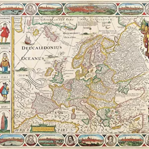
Map: Milford Haven, from the Admiralty and Ordnance Surveys; Pembroke, Dockyard (colour litho)
")
![]()
Wall Art and Photo Gifts from Fine Art Finder
Map: Milford Haven, from the Admiralty and Ordnance Surveys; Pembroke, Dockyard (colour litho)
6004700 Map: Milford Haven, from the Admiralty and Ordnance Surveys; Pembroke, Dockyard (colour litho) by English School, (19th century); Private Collection; (add.info.: Milford Haven, from the Admiralty and Ordnance Surveys; Pembroke, Dockyard. Illustration for A Gazetteer of the World or Dictionary of Geographical Knowledge (A Fullarton, 1858).); © Look and Learn; English, out of copyright
Media ID 22771708
© Look and Learn / Bridgeman Images
1850s Admiralty Milford Haven Victoria
FEATURES IN THESE COLLECTIONS
> Arts
> Artists
> Related Images
> Europe
> United Kingdom
> Wales
> Pembrokeshire
> Milford Haven
> Europe
> United Kingdom
> Wales
> Pembrokeshire
> Pembroke
> Fine Art Finder
> Artists
> English School
> Maps and Charts
> Early Maps
> Maps and Charts
> Related Images
> Maps and Charts
> World
EDITORS COMMENTS
This print showcases a meticulously detailed map titled "Milford Haven, from the Admiralty and Ordnance Surveys; Pembroke, Dockyard". Created by an anonymous English School artist in the 19th century, this color lithograph is now part of a private collection. The map was originally featured in A Gazetteer of the World or Dictionary of Geographical Knowledge published by A Fullarton in 1858. The intricate illustration offers a glimpse into the historical significance of Milford Haven during the mid-19th century. As one explores this fascinating piece, they are transported back to a time when Victoria reigned over Britain and maritime trade flourished. The map provides valuable insights into the geography and topography of Milford Haven, with particular focus on its connection to Pembroke Dockyard. Every contour line and minute detail has been carefully etched onto this artwork, showcasing both skillful craftsmanship and dedication to accuracy. It serves as a testament to the importance placed on cartography during that era. This remarkable image not only appeals to history enthusiasts but also captures the imagination of those intrigued by maps and their ability to transport us through time. With its rich colors and meticulous attention to detail, this print allows viewers to explore Milford Haven's past while appreciating its enduring beauty.
MADE IN THE USA
Safe Shipping with 30 Day Money Back Guarantee
FREE PERSONALISATION*
We are proud to offer a range of customisation features including Personalised Captions, Color Filters and Picture Zoom Tools
SECURE PAYMENTS
We happily accept a wide range of payment options so you can pay for the things you need in the way that is most convenient for you
* Options may vary by product and licensing agreement. Zoomed Pictures can be adjusted in the Cart.