Home > Africa > Egypt > Alexandria
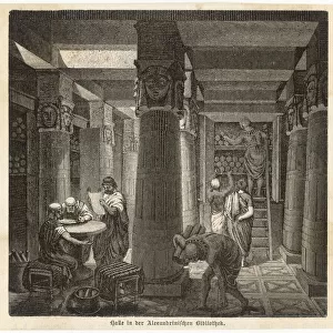
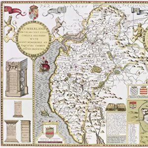
Map of the world, based on descriptions and co-ordinates given in Geographia

![]()
Wall Art and Photo Gifts from Fine Art Finder
Map of the world, based on descriptions and co-ordinates given in Geographia
NBY259407 Map of the world, based on descriptions and co-ordinates given in Geographia first published in Ulm, Germany, 1482 (colour litho) by Ptolemy (Claudius Ptolemaeus of Alexandria)(c.90-168)(after); Newberry Library, Chicago, Illinois, USA; (add.info.: book by Ptolemy (Claudius Ptolemaeus of Alexandria) (c.90-168 AD); ); eNewberry Library; Greek, out of copyright
Media ID 23374330
© Newberry Library / Bridgeman Images
Atlas Continents Roman Egypt Winds Cherubim Cherubs Coordinates
FEATURES IN THESE COLLECTIONS
> Africa
> Egypt
> Alexandria
> Africa
> Egypt
> Related Images
> Arts
> Art Movements
> Renaissance Art
> Arts
> Artists
> R
> Roman Roman
> Europe
> Greece
> Related Images
> Fine Art Finder
> Artists
> (c.90-168)(after) Ptolemy
> Fine Art Finder
> Artists
> Photographer American
> Fine Art Finder
> Maps (celestial & Terrestrial)
EDITORS COMMENTS
This print showcases a remarkable "Map of the world, based on descriptions and co-ordinates given in Geographia" originally published in Ulm, Germany in 1482. Created by the renowned Ptolemy (Claudius Ptolemaeus of Alexandria), this map is a testament to his extensive knowledge and expertise. The intricate details depicted on this map take us back to the Renaissance era, where cartography was an art form. Every continent is meticulously outlined, allowing viewers to explore the vastness of our planet through Ptolemy's eyes. The accuracy with which he captured geographical coordinates is truly impressive considering the limited technology available during that time. As we delve deeper into this masterpiece, we are greeted by cherubs and cherubim gracefully adorning its corners. These celestial beings add a touch of enchantment to an already awe-inspiring piece. Their presence reminds us that maps not only serve as navigational tools but also inspire curiosity and wonder about the world beyond our reach. Preserved at the Newberry Library in Chicago, Illinois, USA, this photograph captures every vibrant color present on the original lithograph. It allows us to appreciate Ptolemy's work from centuries ago while marveling at how far cartography has come since then. This print serves as a reminder of humanity's unquenchable thirst for exploration and discovery—a timeless tribute to those who have dedicated their lives to understanding our magnificent world.
MADE IN THE USA
Safe Shipping with 30 Day Money Back Guarantee
FREE PERSONALISATION*
We are proud to offer a range of customisation features including Personalised Captions, Color Filters and Picture Zoom Tools
SECURE PAYMENTS
We happily accept a wide range of payment options so you can pay for the things you need in the way that is most convenient for you
* Options may vary by product and licensing agreement. Zoomed Pictures can be adjusted in the Cart.