Home > Arts > Artists > A > John White Alexander
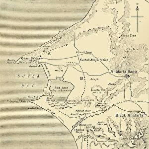
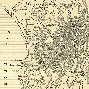
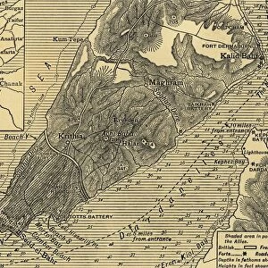
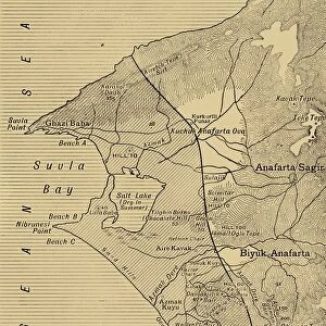
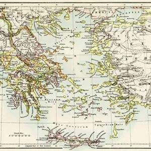
Detailed Map of Gallipoli and Dardanelles, 1916. Creator: Unknown

![]()
Wall Art and Photo Gifts from Heritage Images
Detailed Map of Gallipoli and Dardanelles, 1916. Creator: Unknown
Detailed Map of Gallipoli and Dardanelles, 1916. The Gallipoli campaign took place on the Gallipoli peninsula from 17 February 1915 to 9 January 1916. From " The War Illustrated Album De Luxe - Volume IV. The Summer Campaign - 1915", edited by J. A. Hammerton. [The Amalgamated Press, Limited, London, 1916]
Heritage Images features heritage image collections
Media ID 19661397
© The Print Collector/Heritage Images
Aegean Sea Album Amalgamated Press Amalgamated Press Limited Amalgamated Press Ltd Coastline Dardanelles Dardanelles Campaign Gallipoli Campaign Gallipoli Peninsula Gallipoli Peninsula Turkey Hammerton Hammerton J A Hammerton Ja Hammerton Sir John Alexander Hellespont J A Hammerton Ja Hammerton John Hammerton Ottoman Sir John Alexander Sir John Alexander Hammerton Sir John Hammerton Strait Strategic Strategy Summer Campaign 1915 The Amalgamated Press The War Illustrated Turkey
FEATURES IN THESE COLLECTIONS
> Arts
> Artists
> A
> John White Alexander
> Arts
> Artists
> W
> John White
> Arts
> Photorealistic artworks
> Detailed art pieces
> Masterful detailing in art
> Asia
> Turkey
> Related Images
> Historic
> World War I and II
> World War I
> Historic
> World War I and II
> Maps and Charts
> Related Images
> Maps and Charts
> World
EDITORS COMMENTS
This print showcases a highly detailed map of Gallipoli and Dardanelles, created in 1916 during the First World War. The Gallipoli campaign, which took place from February 17,1915, to January 9,1916, is depicted on this historical map. It was featured in "The War Illustrated Album De Luxe - Volume IV: The Summer Campaign - 1915", edited by J. A. Hammerton. The map provides a comprehensive overview of the strategic coastline along the Gallipoli peninsula in Turkey, highlighting key geographical features such as the Aegean Sea and Hellespont Strait (also known as Dardanelles). This vital region played a significant role in military operations during the war. Although the creator of this remarkable piece remains unknown, its value lies in its ability to convey important information about wartime strategy and military movements. With intricate details and precise markings denoting various locations and routes used by Ottoman forces and their adversaries, it serves as an invaluable resource for historians studying this period. Preserved through time by Heritage Images' collection, this print offers viewers a glimpse into one of history's most notable conflicts. As we observe this relic from over a century ago, we are reminded of the sacrifices made during World War I while gaining insight into the complex dynamics that shaped global events at that time.
MADE IN THE USA
Safe Shipping with 30 Day Money Back Guarantee
FREE PERSONALISATION*
We are proud to offer a range of customisation features including Personalised Captions, Color Filters and Picture Zoom Tools
SECURE PAYMENTS
We happily accept a wide range of payment options so you can pay for the things you need in the way that is most convenient for you
* Options may vary by product and licensing agreement. Zoomed Pictures can be adjusted in the Cart.