Home > Animals > Birds > Passerines > New Zealand Wrens > Rifleman
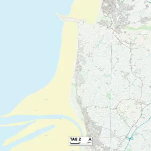
Pembrokeshire SA61 1 Map

![]()
Wall Art and Photo Gifts from Map Marketing
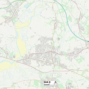
Pembrokeshire SA61 1 Map
Postcode Sector Map of Pembrokeshire SA61 1
Media ID 19979739
A487 Abbots Close Addison Road Albert Street Barn Street Byron Road Church Lane Clay Lane Dale Road Deans Close Ellis Avenue Fir Tree Close Glen View Greenhill Crescent Haven Road Hill Lane Hill Street Horns Lane Jenkins Close Keats Grove Laburnum Grove Laurel Drive Longfellow Close Magdalen Street Maple Avenue Market Street Masefield Drive Milford Road Mill Lane Milton Close New Road Palmerston Road Pembroke Road Pembrokeshire Priory Avenue Quay Street Richmond Crescent Rose Avenue Rosemary Lane Shakespeare Close Shelley Road Snowdrop Close St Margarets Close St Marks Close Tower Hill Tudor Gardens Tudor Way Windsor Way Woodlands Park Wordsworth Avenue New Quay St Marks Church Union Hill
FEATURES IN THESE COLLECTIONS
> Animals
> Birds
> Passerines
> New Zealand Wrens
> Rifleman
> Architecture
> Towers
> Churches
> Architecture
> Towers
> Tower Bridge
> Arts
> Artists
> H
> Thomas Hill
> Arts
> Artists
> H
> Thomas Horner
> Europe
> United Kingdom
> England
> London
> Sights
> Richmond Park
> Europe
> United Kingdom
> England
> London
> Sights
> Tower Bridge
> Europe
> United Kingdom
> Wales
> Ceredigion
> New Quay
> Europe
> United Kingdom
> Wales
> Pembrokeshire
> Hakin
> Europe
> United Kingdom
> Wales
> Pembrokeshire
> Milford Haven
> Map Marketing
> Postcode Sector Maps
> SA - Swansea
MADE IN THE USA
Safe Shipping with 30 Day Money Back Guarantee
FREE PERSONALISATION*
We are proud to offer a range of customisation features including Personalised Captions, Color Filters and Picture Zoom Tools
SECURE PAYMENTS
We happily accept a wide range of payment options so you can pay for the things you need in the way that is most convenient for you
* Options may vary by product and licensing agreement. Zoomed Pictures can be adjusted in the Cart.