Home > North America > United States of America > Maps
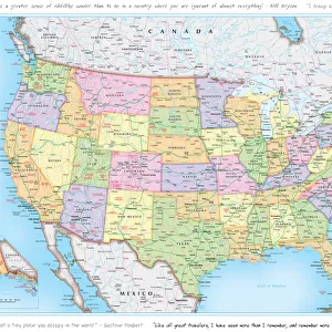
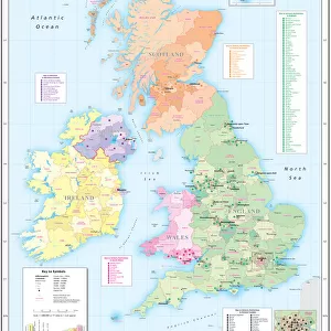
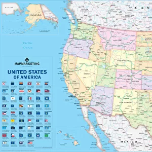
USA Political Map

![]()
Wall Art and Photo Gifts from Map Marketing
USA Political Map
This very clean and clear USA political map shows each State in a different colour as well as principal cities and towns divided into six separate population bands. It also shows the main road network with Interstate highways highlighted, railways, main airports, State capitals, State and international boundaries are all marked. The USA political map also includes a key panel showing the flag for each US State detailing the State capital, population and geographical size
Media ID 19951695
© Map Marketing Ltd
FEATURES IN THESE COLLECTIONS
> Maps and Charts
> Related Images
> North America
> United States of America
> Maps
> Popular Themes
> Railway Posters
MADE IN THE USA
Safe Shipping with 30 Day Money Back Guarantee
FREE PERSONALISATION*
We are proud to offer a range of customisation features including Personalised Captions, Color Filters and Picture Zoom Tools
SECURE PAYMENTS
We happily accept a wide range of payment options so you can pay for the things you need in the way that is most convenient for you
* Options may vary by product and licensing agreement. Zoomed Pictures can be adjusted in the Cart.