Home > Europe > United Kingdom > England > London > Towns > Welling
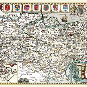
Old County Map of Derbyshire 1836 by Thomas Moule

![]()
Wall Art and Photo Gifts from MapSeeker
Old County Map of Derbyshire 1836 by Thomas Moule
This is a fine decorative reproduction County Map of Derbyshire from the First Edition series of Thomas Moule Maps, originally Published in 1836. The well-known series of County Maps which are known as Moules feature beautiful vignette views and were first published in separate sections for each county in 1830-32, they were then published in collected form in a two-volume work: The English Counties Delineated: or a Topographical Description of England: Illustrated by a Complete Series of County Maps by Thomas Moule: London: Published by George Virtue 1836
Welcome to the Mapseeker Image library and enter an historic gateway to one of the largest on-line collections of Historic Maps, Nostalgic Views, Vista's and Panorama's from a World gone by.
Media ID 20348056
© Mapseeker Publishing Ltd
County Map County Map Of England English County Map Historic Map Moule Map Old County Map Old English County Map Old Moule Map Thomas Moule Thomas Moule Map Derbyshire
FEATURES IN THESE COLLECTIONS
> Arts
> Artists
> M
> Thomas Moule
> Europe
> United Kingdom
> England
> Derbyshire
> Related Images
> Europe
> United Kingdom
> England
> London
> Towns
> Welling
> Europe
> United Kingdom
> England
> Maps
> Europe
> United Kingdom
> England
> Wells
> Maps and Charts
> Early Maps
> Maps and Charts
> Related Images
> MapSeeker
> Maps from the British Isles
> England and Counties PORTFOLIO
EDITORS COMMENTS
This beautifully crafted reproduction of the "Old County Map of Derbyshire 1836" by Thomas Moule takes us back in time to explore the historical landscape of this English county. Originally published as part of a groundbreaking series, these maps were highly regarded for their intricate details and captivating vignette views. Thomas Moule's passion for cartography shines through in this meticulously drawn map, which showcases the topographical features and landmarks that defined Derbyshire during the early 19th century. From its rolling hills to its charming villages, every corner is brought to life with remarkable accuracy. Published in 1836 by George Virtue, this particular edition captures the essence of Moule's work. The map was originally released as individual sections for each county before being compiled into a comprehensive two-volume collection titled "The English Counties Delineated: or a Topographical Description of England". This timeless piece remains an invaluable resource for historians and enthusiasts alike. As we gaze upon this historic masterpiece, we are transported back to an era when horse-drawn carriages traversed winding roads and bustling market towns dotted the countryside. It serves as a reminder of our rich heritage and offers a glimpse into how Derbyshire has evolved over time. Whether you have personal ties to Derbyshire or simply appreciate fine craftsmanship, this old county map is sure to captivate your imagination and spark curiosity about our shared past.
MADE IN THE USA
Safe Shipping with 30 Day Money Back Guarantee
FREE PERSONALISATION*
We are proud to offer a range of customisation features including Personalised Captions, Color Filters and Picture Zoom Tools
SECURE PAYMENTS
We happily accept a wide range of payment options so you can pay for the things you need in the way that is most convenient for you
* Options may vary by product and licensing agreement. Zoomed Pictures can be adjusted in the Cart.