Home > Europe > United Kingdom > England > London > Towns > Clapham
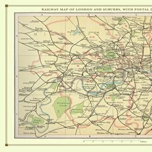
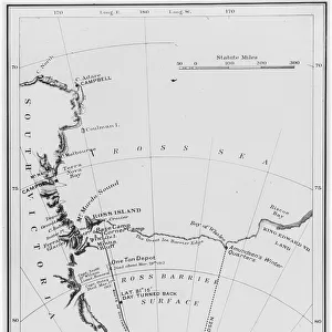
Railway map, Clapham Junction area, London

![]()
Wall Art and Photo Gifts from Mary Evans Picture Library
Railway map, Clapham Junction area, London
Railway map, Clapham Junction, Stewarts Lane, Lavender Hill and Longhedge, SW London, with colour coding of the various railway companies. Date: 1912
Mary Evans Picture Library makes available wonderful images created for people to enjoy over the centuries
Media ID 23144176
© Mary Evans / Pharcide
Basin Battersea Chelsea Clapham Coal Depot Goods Inset Junction Junctions Lane Lavender Lines Links Maps Pier Wharf Stewarts
FEATURES IN THESE COLLECTIONS
> Arts
> Landscape paintings
> Waterfall and river artworks
> River artworks
> Europe
> United Kingdom
> England
> London
> Boroughs
> Kensington and Chelsea
> Europe
> United Kingdom
> England
> London
> Related Images
> Europe
> United Kingdom
> England
> London
> River Thames
> Europe
> United Kingdom
> England
> London
> Towns
> Battersea
> Europe
> United Kingdom
> England
> London
> Towns
> Chelsea
> Europe
> United Kingdom
> England
> London
> Towns
> Clapham
> Europe
> United Kingdom
> England
> London
> Transport
> Railway
> Maps and Charts
> Related Images
> Mary Evans Prints Online
> New Images August 2021
> Popular Themes
> Railway Posters
MADE IN THE USA
Safe Shipping with 30 Day Money Back Guarantee
FREE PERSONALISATION*
We are proud to offer a range of customisation features including Personalised Captions, Color Filters and Picture Zoom Tools
SECURE PAYMENTS
We happily accept a wide range of payment options so you can pay for the things you need in the way that is most convenient for you
* Options may vary by product and licensing agreement. Zoomed Pictures can be adjusted in the Cart.