Home > Science > Space Exploration > Planets > Earth
Earth, topographic and bathymetric map

![]()
Wall Art and Photo Gifts from Science Photo Library
Earth, topographic and bathymetric map
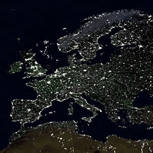
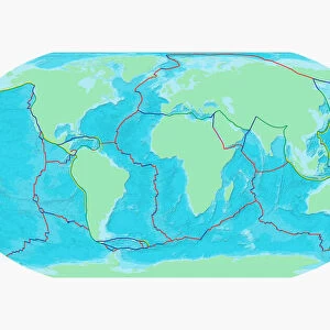
Earth, topographic and bathymetric map. This map is centred on the Pacific Ocean, at longitude 140 degrees west. Highlands and lowlands of the continents are shown as ridges and flat areas, with Arctic and Antarctic ice in white. The seabed depth varies from shallow (light blue) on the continental shelves, to deep ocean basins (dark blue). Topographic and bathymetric data is usually gathered by using aerial and satellite imagery combined with radar and sonar mapping. The satellites in this case were NOas POES satellites
Science Photo Library features Science and Medical images including photos and illustrations
Media ID 1705093
© PLANETARY VISIONS LTD/SCIENCE PHOTO LIBRARY
Altimetric Altimetry Basin Bathymetric Bathymetry Combined Data Continent Continental Shelf Continents Data Depth Depths Floor Global Globe Highlands Land Lowlands Mapped Mountains Noaa Oceanic Oceanographic Oceanography Pacific Ocean Physical Geography Plains Poes Radar Region Ridge Satellite Satellite Image Sea Bed Sea Floor Shelves Sonar Mapping Sonic Topographic Topography Whole Earth World World Wide
FEATURES IN THESE COLLECTIONS
> Aerial Photography
> Related Images
> Animals
> Mammals
> Muridae
> Plains Mouse
> Arts
> Artists
> O
> Oceanic Oceanic
> Europe
> France
> Canton
> Landes
> Europe
> United Kingdom
> Scotland
> Highlands
> Related Images
> Maps and Charts
> Flat Earth
> Maps and Charts
> Related Images
> Maps and Charts
> World
> Science Photo Library
> Aerial and Satellite
> Science
> Space Exploration
> Planets
> Earth
EDITORS COMMENTS
This stunning topographic and bathymetric map depicts the Pacific Ocean, centered at longitude 140 degrees west. The map showcases the intricate interplay of Earth's land and marine topography, with continents represented as ridges and flat areas, and Arctic and Antarctic ice caps appearing in pristine white. The seabed depth varies from shallow, light blue waters on the continental shelves to deep ocean basins, shown in dark blue. Topographic and bathymetric data for this map was gathered using a combination of aerial and satellite imagery, along with radar and sonar mapping. In particular, data from NOAA's POES (Polar-orbiting Operational Environmental Satellites) was employed to create this comprehensive, whole Earth representation. The Eckert III projection was used to accurately represent the spherical Earth on a flat map, ensuring that the shapes and sizes of landmasses and oceanic features are as true-to-life as possible. The continents' highlands and lowlands, including mountains and plains, are clearly visible, providing a comprehensive overview of the physical geography of our planet. The Pacific Ocean, as the largest and deepest of all the world's ocean basins, is particularly well-represented in this map. The continental shelves, which gradually slope from the land to the deep ocean, are shown in detail, with their varying depths indicated by the color gradation from light to dark blue. The deep ocean basins, home to some of the most extreme environments on Earth, are depicted in their full, dark glory. This map is a testament to the power of combined data from multiple sources and advanced mapping techniques, offering a unique perspective on the intricacies of our world's topography and bathymetry.
MADE IN THE USA
Safe Shipping with 30 Day Money Back Guarantee
FREE PERSONALISATION*
We are proud to offer a range of customisation features including Personalised Captions, Color Filters and Picture Zoom Tools
SECURE PAYMENTS
We happily accept a wide range of payment options so you can pay for the things you need in the way that is most convenient for you
* Options may vary by product and licensing agreement. Zoomed Pictures can be adjusted in the Cart.