Home > Universal Images Group (UIG) > Art > Painting, Sculpture & Prints > Cartography
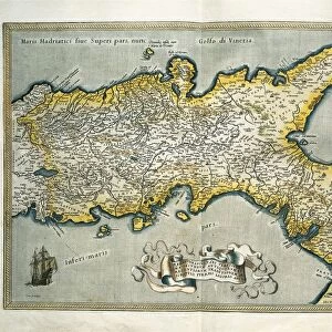
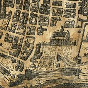
Map of Genoa in 1656, partly revised in 1766

![]()
Wall Art and Photo Gifts from Universal Images Group (UIG)
Map of Genoa in 1656, partly revised in 1766
Cartography, Italy, 17th-18th century. Map of Genoa in 1656, partly revised in 1766
Universal Images Group (UIG) manages distribution for many leading specialist agencies worldwide
Media ID 9454763
© DEA / A. DE GREGORIO
17th Century 18th Century Compass Rose Genoa Liguria Mediterranean Sea Nautical Vessel Port Sailing Boat Western Script
EDITORS COMMENTS
This print showcases a remarkable piece of cartography, the "Map of Genoa in 1656, partly revised in 1766". A testament to Italy's rich history and artistic prowess during the 17th and 18th centuries, this studio shot captures the full length of the map with exquisite detail. The map itself is a stunning blend of art and science, meticulously illustrating the physical geography of Genoa and its surrounding areas. The city's bustling port comes to life as sailing boats gracefully glide across the sea, reminding us of Genoa's historical significance as a maritime powerhouse. Every element on this map tells a story - from intricate compass roses indicating cardinal directions to delicate illustrations depicting nautical vessels navigating through Liguria's waters. The use of Western script adds an air of sophistication while providing essential information for navigation. As we gaze upon this masterpiece, we are transported back in time, immersed in an era when cartography was not only functional but also an art form. This print serves as a window into the past, allowing us to appreciate both the craftsmanship involved in creating such maps and their importance in understanding our world. With no people present within its frame, this image invites us to explore history through our own imagination. It reminds us that even though time may have passed since these maps were created, their beauty and relevance endure.
MADE IN THE USA
Safe Shipping with 30 Day Money Back Guarantee
FREE PERSONALISATION*
We are proud to offer a range of customisation features including Personalised Captions, Color Filters and Picture Zoom Tools
SECURE PAYMENTS
We happily accept a wide range of payment options so you can pay for the things you need in the way that is most convenient for you
* Options may vary by product and licensing agreement. Zoomed Pictures can be adjusted in the Cart.