Home > Universal Images Group (UIG) > Art > Painting, Sculpture & Prints > Cartography
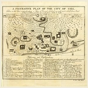
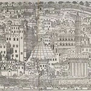
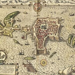
Map of Goa City, from Scoperte dei Portoghesi, Discoveries of the Portuguese, printed in Italy, 1733

![]()
Wall Art and Photo Gifts from Universal Images Group (UIG)
Map of Goa City, from Scoperte dei Portoghesi, Discoveries of the Portuguese, printed in Italy, 1733
Cartography, Italy, 18th century. Goa City. From Scoperte dei Portoghesi (Discoveries of the Portuguese), 1733
Universal Images Group (UIG) manages distribution for many leading specialist agencies worldwide
Media ID 9500555
© DEA / A. DAGLI ORTI
18th Century Aerial View City Cityscape Colonialism Direction Guidance Harbor Sailing Ship Transportation
EDITORS COMMENTS
This print showcases a historical gem - the Map of Goa City, printed in Italy in 1733. A testament to the era of colonialism and discovery, this map offers a glimpse into the rich history and vibrant culture of Goa during the 18th century. With its intricate details and expert cartography, this piece serves as both an art form and a valuable tool for navigation. The map provides guidance to travelers seeking adventure or merchants searching for new trade routes. Its depiction of transportation options highlights the importance of harbors and sea travel in connecting different parts of the world. The aerial view captured in this image allows us to appreciate the physical geography that shaped Goa City's development. From bustling cityscapes to serene coastlines, every corner is meticulously illustrated with precision and care. As we gaze upon this remarkable work, we are transported back in time when sailing ships dominated these waters. It reminds us not only of past discoveries but also emphasizes how far we have come in terms of technological advancements. This print from Universal Images Group (UIG) is a true masterpiece that encapsulates history, artistry, and exploration all within its frame. It invites us to reflect on our roots while appreciating how maps continue to guide our journeys today.
MADE IN THE USA
Safe Shipping with 30 Day Money Back Guarantee
FREE PERSONALISATION*
We are proud to offer a range of customisation features including Personalised Captions, Color Filters and Picture Zoom Tools
SECURE PAYMENTS
We happily accept a wide range of payment options so you can pay for the things you need in the way that is most convenient for you
* Options may vary by product and licensing agreement. Zoomed Pictures can be adjusted in the Cart.