Home > Europe > United Kingdom > Wales > Gwent > Newport
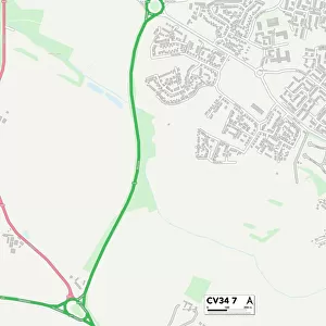
Coventry CV6 4 Map

![]()
Wall Art and Photo Gifts from Map Marketing
Coventry CV6 4 Map
Postcode Sector Map of Coventry CV6 4
Media ID 19968113
Alderney Close Beacon Road Bentley Court Birkdale Close Blenheim Avenue Buckland Road Coventry Dunlop Close Farndale Avenue Forge Way Foxglove Close Giles Close Greenwood Place Hallam Road Harborough Road Holborn Avenue Jackson Road Kingswood Close Langdale Avenue Meadow Road Morland Road Newport Road Orton Road Park Avenue Parkgate Road Parkland Close Roland Avenue Romford Road Rookery Lane Rotherham Road Selworthy Road Sharp Close St Lukes Road Sunningdale Avenue Swallow Road Wentworth Drive West Avenue Yelverton Road Central Boulevard Holbrooks
FEATURES IN THESE COLLECTIONS
> Animals
> Fishes
> S
> Swallower
> Arts
> Artists
> G
> John Greenwood
> Arts
> Artists
> J
> John Jackson
> Europe
> United Kingdom
> Wales
> Gwent
> Newport
> Europe
> United Kingdom
> Wales
> Pembrokeshire
> Newport
> Map Marketing
> Postcode Sector Maps
> CV - Coventry
> Map Marketing
> UK Maps
> Maps and Charts
> Related Images
MADE IN THE USA
Safe Shipping with 30 Day Money Back Guarantee
FREE PERSONALISATION*
We are proud to offer a range of customisation features including Personalised Captions, Color Filters and Picture Zoom Tools
SECURE PAYMENTS
We happily accept a wide range of payment options so you can pay for the things you need in the way that is most convenient for you
* Options may vary by product and licensing agreement. Zoomed Pictures can be adjusted in the Cart.