Home > Historic > Ancient civilizations > Ancient Greece > Greek history
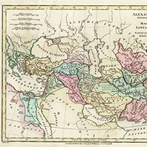
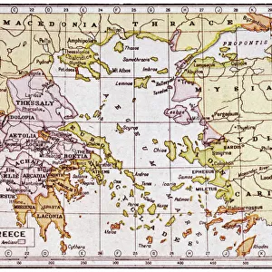
Map of the Macedonian and Thracian Empire

![]()
Wall Art and Photo Gifts from Mary Evans Picture Library
Map of the Macedonian and Thracian Empire
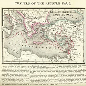
Map of the Macedonian and Thracian Empire. Date: 1808
Mary Evans Picture Library makes available wonderful images created for people to enjoy over the centuries
Media ID 11575337
© Mary Evans / Grenville Collins Postcard Collection
1808 Aegean Balkan Balkans Byzantium Chart Dacia Epirus Illyria Ionian Macedonia Macedonian Maps Thracian
FEATURES IN THESE COLLECTIONS
> Europe
> Greece
> Related Images
> Europe
> Macedonia
> Posters
> Europe
> Macedonia
> Related Images
> Europe
> Related Images
> Historic
> Ancient civilizations
> Ancient Greece
> Greek history
> Maps and Charts
> Early Maps
EDITORS COMMENTS
This map print, dated 1808, offers a glimpse into the rich historical tapestry of the Macedonian and Thracian Empire, a vast territory that once stretched across Central Europe and the Balkan Peninsula. The map meticulously delineates the borders of ancient civilizations, including Macedonia, Thrace, Epirus, Thessalia, Illyrium, Dacia, and more. Macedonia, located in the northern part of the map, was a significant ancient kingdom that flourished from the 8th to the 14th centuries BC. It was renowned for its powerful rulers, such as Alexander the Great, who expanded the Macedonian Empire to include much of the ancient world. Thrace, situated to the east, was a diverse region inhabited by various tribes, including the Thracians, who were known for their warrior culture and gold mining. Thessalia, to the west, was a fertile plain that was a center of Greek civilization. Illyrium, to the south, was a region inhabited by the Illyrians, who were known for their resistance to Roman rule. Dacia, located north of the Danube River, was a powerful and prosperous kingdom that was annexed by the Romans in AD 106. The map also highlights key geographical features, such as the Aegean Sea, the Ionian Sea, and the Byzantium Straits. These bodies of water played crucial roles in the economic and cultural exchange between the various civilizations of the region. This map is an invaluable resource for anyone interested in ancient history, particularly the history of Central Europe and the Balkans. It provides a fascinating glimpse into the complex and interconnected world of ancient civilizations and offers a reminder of the rich cultural heritage that continues to shape our world today.
MADE IN THE USA
Safe Shipping with 30 Day Money Back Guarantee
FREE PERSONALISATION*
We are proud to offer a range of customisation features including Personalised Captions, Color Filters and Picture Zoom Tools
SECURE PAYMENTS
We happily accept a wide range of payment options so you can pay for the things you need in the way that is most convenient for you
* Options may vary by product and licensing agreement. Zoomed Pictures can be adjusted in the Cart.