Home > Europe > United Kingdom > England > London > Politics > John Russell
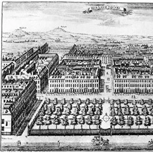
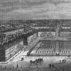
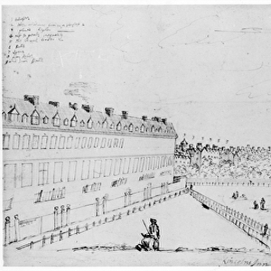
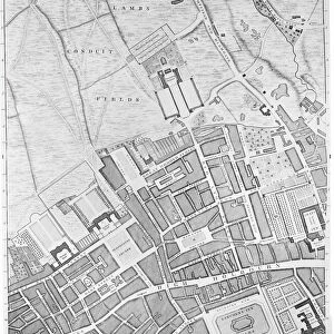
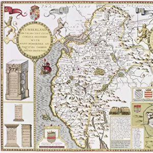
A Map of Bloomsbury and Holborn, London, 1746 (engraving)
")
![]()
Wall Art and Photo Gifts from Fine Art Finder
A Map of Bloomsbury and Holborn, London, 1746 (engraving)
XJF438445 A Map of Bloomsbury and Holborn, London, 1746 (engraving) by Rocque, John (c.1704-d.1762); Private Collection; (add.info.: the map shows the Foundling Hospital, a home for unwanted children, established by Thomas Coram in the 1740s; ); British, out of copyright
Media ID 12881121
© www.bridgemanimages.com
1740s Aerial View Bloomsbury Childrens Home Established Foundling Hospital Grays Inn Great Ormond Street Great Russell Street High Holborn Holborn Lincolns Inn Fields Russell Square Thomas Coram Unwanted Newly Built Queens Square
FEATURES IN THESE COLLECTIONS
> Aerial Photography
> Related Images
> Arts
> Artists
> F
> John Field
> Arts
> Artists
> G
> Thomas Gray
> Arts
> Artists
> R
> John Rocque
> Arts
> Artists
> R
> John Russell
> Arts
> Portraits
> Pop art gallery
> Street art portraits
> Europe
> United Kingdom
> England
> London
> Hospitals
> Europe
> United Kingdom
> England
> London
> Politics
> John Russell
> Fine Art Finder
> Artists
> John Rocque
> Fine Art Finder
> Maps (celestial & Terrestrial)
> Maps and Charts
> Related Images
EDITORS COMMENTS
This engraving, titled "A Map of Bloomsbury and Holborn, London, 1746" takes us on a journey back in time to the bustling streets of 18th-century London. Created by John Rocque, this detailed map showcases the vibrant neighborhoods of Bloomsbury and Holborn during an era of significant growth and development. One notable feature depicted on this map is the Foundling Hospital, a compassionate institution established by Thomas Coram in the 1740s. This home for unwanted children provided shelter and care for those who had been abandoned or orphaned. The presence of this remarkable establishment serves as a reminder of both the hardships faced by vulnerable children at that time and the compassion shown by individuals like Coram. As we explore further into Rocque's intricate artwork, we encounter other landmarks such as Lincoln's Inn Fields, High Holborn, Red Lyon Square, Russell Square, Great Ormond Street, Gray's Inn, Great Russell Street, Conduit Fields Road - each representing a piece of London's rich history. From an aerial perspective captured within this print emerges a vivid snapshot showcasing Lambs Fields and St. Giles Church among various other locations that were integral to daily life in these neighborhoods centuries ago. With its historical significance and attention to detail capturing every street corner with precision; this enchanting engraving offers viewers an opportunity to immerse themselves in the past while appreciating Rocque's skillful artistry.
MADE IN THE USA
Safe Shipping with 30 Day Money Back Guarantee
FREE PERSONALISATION*
We are proud to offer a range of customisation features including Personalised Captions, Color Filters and Picture Zoom Tools
SECURE PAYMENTS
We happily accept a wide range of payment options so you can pay for the things you need in the way that is most convenient for you
* Options may vary by product and licensing agreement. Zoomed Pictures can be adjusted in the Cart.