Home > Europe > United Kingdom > England > London > Sights > British Museum
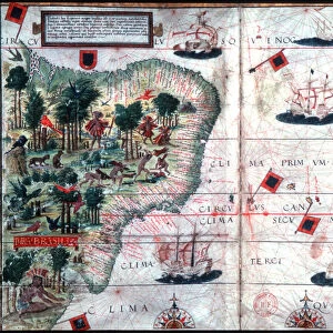
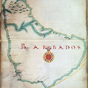
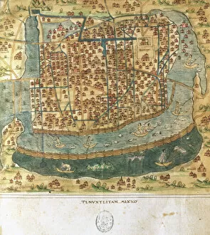
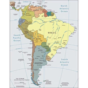
French Map of Central and South America, French, 1550

![]()
Wall Art and Photo Gifts from Heritage Images
French Map of Central and South America, French, 1550
French Map of Central and South America, French, 1550. Map showing Florida, the Gulf of Mexico, the Caribbean islands and Antilles, and South America with the River Plate prominent. It features illustrations including conquistadors in Peru, cannibals, gold mines and parrots. From the British Museum
Heritage Images features heritage image collections
Media ID 14847392
© Ann Ronan Picture Library / Heritage-Images
Cannibal Cannibalism Caribbean Cartography Central America Chart Colonisation Conquest Conquistador Discovery Exploration Invader Invaders Invasion Island Map Making Navigation River Plate Western Hemisphere Ann Ronan Pictures
FEATURES IN THESE COLLECTIONS
> Animals
> Mammals
> Muridae
> Water Mouse
> Animals
> Mammals
> Muridae
> Western Mouse
> Arts
> Landscape paintings
> Waterfall and river artworks
> River artworks
> Europe
> United Kingdom
> England
> London
> Sights
> British Museum
> Maps and Charts
> Related Images
> North America
> Mexico
> Maps
> North America
> Mexico
> Related Images
EDITORS COMMENTS
This print showcases a remarkable French Map of Central and South America, dating back to 1550. The map provides an intricate depiction of the region, highlighting significant geographical features such as Florida, the Gulf of Mexico, the Caribbean islands and Antilles, as well as South America with a prominent focus on the River Plate. What makes this map truly fascinating are its vivid illustrations that bring history to life. From conquistadors in Peru to cannibals, gold mines to parrots, each detail offers a glimpse into the exploration and conquests that took place during this era. It is evident that this map served not only as a navigational tool but also as a visual representation of discovery. Created by an unknown cartographer from France, this piece exemplifies the artistry and precision involved in map making during the 16th century. Its vibrant colors and meticulous attention to detail make it both aesthetically pleasing and historically significant. As we delve into this image, we are transported back in time – witnessing European invasions and colonizations unfold before our eyes. This print serves as a reminder of how exploration shaped our world today while shedding light on cultural encounters between native populations and foreign conquerors. Preserved by the British Museum, this French Map offers us valuable insights into past civilizations' understanding of geography while capturing their ambitions for expansion across continents through water transport via ships.
MADE IN THE USA
Safe Shipping with 30 Day Money Back Guarantee
FREE PERSONALISATION*
We are proud to offer a range of customisation features including Personalised Captions, Color Filters and Picture Zoom Tools
SECURE PAYMENTS
We happily accept a wide range of payment options so you can pay for the things you need in the way that is most convenient for you
* Options may vary by product and licensing agreement. Zoomed Pictures can be adjusted in the Cart.