Home > Arts > Landscape paintings > Waterfall and river artworks > Nature-inspired paintings
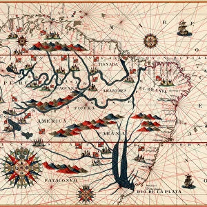
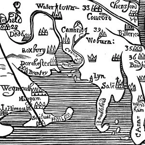
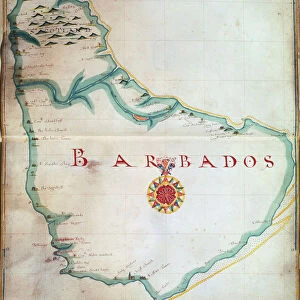
Map of the east coast of North America, early 16th century

![]()
Wall Art and Photo Gifts from Heritage Images
Map of the east coast of North America, early 16th century
Map of the east coast of North America, early 16th century. Map of pre-1547 based on Jacques Cartiers discoveries of 1534-1541, showing the coastline from Labrador to Cape Florida and featuring the mouth of the St Lawrence river
Heritage Images features heritage image collections
Media ID 14845568
© Ann Ronan Picture Library / Heritage-Images
Cartography Chart Coastline Discovery Exploration Jacques Map Making Navigation North America Ann Ronan Pictures Cartier Jacques Cartier
FEATURES IN THESE COLLECTIONS
> Animals
> Mammals
> Muridae
> Water Mouse
> Arts
> Landscape paintings
> Waterfall and river artworks
> Nature-inspired paintings
> Arts
> Landscape paintings
> Waterfall and river artworks
> River artworks
> Maps and Charts
> Early Maps
> Maps and Charts
> Related Images
EDITORS COMMENTS
This print showcases a remarkable piece of cartographic history - the "Map of the east coast of North America, early 16th century". Created by Jacques Cartier, a renowned explorer and navigator, this map is based on his groundbreaking discoveries between 1534 and 1541. The intricate details depicted in this map offer an invaluable glimpse into the geographical knowledge of that era. It vividly illustrates the coastline from Labrador to Cape Florida, encompassing various landmarks such as the mouth of the St Lawrence River. The vibrant colors used in this print bring life to both land and water, emphasizing the beauty and diversity found along these shores. As we delve deeper into this image, it becomes evident that exploration was not limited to nature alone. Native people are portrayed engaging with European sailors aboard their sailing ships. This interaction serves as a testament to the cultural exchange that occurred during these expeditions. Transportation played a pivotal role in enabling these voyages across vast oceans, connecting continents like Europe with uncharted territories in North America. The presence of multiple ships signifies both adventure and risk-taking inherent in maritime exploration during the sixteenth century. This print preserves an important chapter in human history when brave explorers like Jacques Cartier pushed boundaries beyond what was known at that time. It reminds us of our innate curiosity about our world's wonders and fuels our desire for further discovery even today.
MADE IN THE USA
Safe Shipping with 30 Day Money Back Guarantee
FREE PERSONALISATION*
We are proud to offer a range of customisation features including Personalised Captions, Color Filters and Picture Zoom Tools
SECURE PAYMENTS
We happily accept a wide range of payment options so you can pay for the things you need in the way that is most convenient for you
* Options may vary by product and licensing agreement. Zoomed Pictures can be adjusted in the Cart.