Home > Arts > Photorealistic artworks > Detailed art pieces > Masterful detailing in art
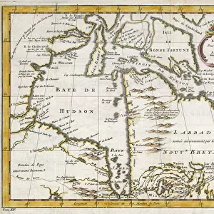
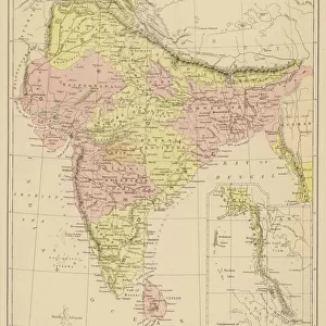
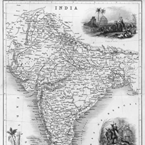
Old Map of Southern India 1852 by Henry George Collins

![]()
Wall Art and Photo Gifts from MapSeeker
Old Map of Southern India 1852 by Henry George Collins
This is a finely detailed map of Southern India remastered from a rare Atlas of the World published in 1852 by Henry George Collins. Although these Henry Collins produced maps of the highest quality in his time unfortunately not the same could be said in terms of his business success. His maps were later obtained by the famous Stanford Map Company and used in their publications
Welcome to the Mapseeker Image library and enter an historic gateway to one of the largest on-line collections of Historic Maps, Nostalgic Views, Vista's and Panorama's from a World gone by.
Media ID 20347265
© Mapseeker Publishing Ltd
Collins Collins Atlas Collins Atlas Map Collins Map South India Southern India
FEATURES IN THESE COLLECTIONS
> Arts
> Photorealistic artworks
> Detailed art pieces
> Masterful detailing in art
> Asia
> India
> Related Images
> Maps and Charts
> India
> Maps and Charts
> Related Images
> Maps and Charts
> World
> MapSeeker
> Maps of Asia and Middle East
> Maps of Countries in Asia PORTFOLIO
EDITORS COMMENTS
This beautifully preserved print showcases an Old Map of Southern India from 1852, meticulously crafted by the talented cartographer Henry George Collins. Despite his exceptional skill in mapmaking, Collins unfortunately did not achieve the same level of success in his business endeavors. However, his remarkable maps were later acquired by the renowned Stanford Map Company and incorporated into their esteemed publications. Remastered from a rare Atlas of the World published in 1852, this particular map offers a captivating glimpse into the historical geography of Southern India during that era. With intricate details and precise markings, it provides a valuable resource for those interested in exploring India's rich past. The map portrays not only Southern India but also its neighboring regions with utmost accuracy. From coastlines to rivers and mountains to cities, every element is intricately illustrated to guide explorers through this enchanting part of the country. Whether you are an avid historian or simply captivated by vintage cartography, this old Indian map holds immense value as both a decorative piece and an educational tool. Its timeless appeal transports us back to a time when exploration was at its peak and serves as a testament to Henry George Collins' undeniable talent as a masterful mapmaker.
MADE IN THE USA
Safe Shipping with 30 Day Money Back Guarantee
FREE PERSONALISATION*
We are proud to offer a range of customisation features including Personalised Captions, Color Filters and Picture Zoom Tools
SECURE PAYMENTS
We happily accept a wide range of payment options so you can pay for the things you need in the way that is most convenient for you
* Options may vary by product and licensing agreement. Zoomed Pictures can be adjusted in the Cart.