Home > Europe > United Kingdom > England > Herefordshire > Maps
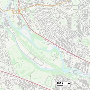
Leeds LS12 2 Map

![]()
Wall Art and Photo Gifts from Map Marketing
Leeds LS12 2 Map
Postcode Sector Map of Leeds LS12 2
Media ID 19974888
Abbott Road Albion Way Beech Avenue Beech Drive Borrowdale Close Branch Road Brandon Street Brooklyn Avenue Canal Road Canal Street Castleton Close Castleton Road Cecil Road Cecil Street Chapel Lane Chester Street Coverdale Close Crab Lane Ely Street Forge Lane Gloucester Terrace Hall Lane Hereford Street Laurel Grove Laurel Place Laurel Street Laurel Terrace Leeds Ley Lane Pickering Street Salisbury Avenue Salisbury Road Salisbury Terrace Stott Street Wensleydale Avenue Wensleydale Close Winchester Street Armley Parliament Place
FEATURES IN THESE COLLECTIONS
> Animals
> Crustaceans
> Crab
> Europe
> United Kingdom
> England
> Herefordshire
> Maps
> Map Marketing
> Postcode Sector Maps
> LS - Leeds
> Maps and Charts
> Related Images
MADE IN THE USA
Safe Shipping with 30 Day Money Back Guarantee
FREE PERSONALISATION*
We are proud to offer a range of customisation features including Personalised Captions, Color Filters and Picture Zoom Tools
SECURE PAYMENTS
We happily accept a wide range of payment options so you can pay for the things you need in the way that is most convenient for you
* Options may vary by product and licensing agreement. Zoomed Pictures can be adjusted in the Cart.