Home > Europe > United Kingdom > England > London > Towns > Mile End
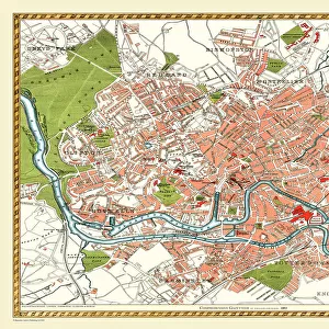
Old Map of Chester 1795 by John Stockdale

![]()
Wall Art and Photo Gifts from MapSeeker
Old Map of Chester 1795 by John Stockdale
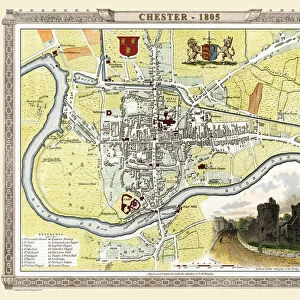
An interesting, very detailed, reproduction 18th century street plan of the City of Chester Engraved for and published John Stockdale, London 1795 for John Aikin s" A Description of the Country from Thirty to Forty Miles Round Manchester" The map covers from the Brewers Hall, River Dee and the Racecourse ( Roodee) to the west of the City to Flokersbrook Bridge, Horn Lane and the end of Foregate Street to the east. Main streets and buildings of interest, such as the Infirmary, the Castle & the Cathedral are also clearly named. Lower right is a reference key which further identifies many more buildings and streets
Welcome to the Mapseeker Image library and enter an historic gateway to one of the largest on-line collections of Historic Maps, Nostalgic Views, Vista's and Panorama's from a World gone by.
Media ID 20347086
Historic Map Old Town Plan Town Plan Chester Stockdale
FEATURES IN THESE COLLECTIONS
> Animals
> Mammals
> Muridae
> Fortior
> Arts
> Photorealistic artworks
> Detailed art pieces
> Masterful detailing in art
> Europe
> United Kingdom
> England
> London
> Towns
> Mile End
> Europe
> United Kingdom
> England
> Manchester
> Manchester
> Historic
> Medieval architecture
> Castles and fortresses
> Historic castles
> Maps and Charts
> Related Images
> MapSeeker
> British Town And City Plans
> English & Welsh PORTFOLIO
> Religious Art
> Religious Architecture
> Churches and Cathedrals
EDITORS COMMENTS
This print showcases an exquisite reproduction of the "Old Map of Chester 1795" by John Stockdale. With remarkable attention to detail, this 18th-century street plan offers a fascinating glimpse into the City of Chester during that era. Published in London by John Stockdale for John Aikin's "A Description of the Country from Thirty to Forty Miles Round Manchester" this map provides a comprehensive view from the Brewers Hall, River Dee, and the Racecourse (Roodee) in the west, all the way to Flokersbrook Bridge, Horn Lane, and Foregate Street in the east. The main streets and notable landmarks such as the Infirmary, Castle, and Cathedral are clearly labeled on this historic map. For further exploration and identification purposes, a reference key is conveniently located at the lower right corner of this print. It unveils additional buildings and streets within Chester that add depth to its historical significance. Whether you are an avid historian or simply intrigued by cartography, this old town plan serves as a window into Chester's past. The craftsmanship displayed in John Stockdale's engraving transports viewers back to a time when horse-drawn carriages traversed these very streets. This exceptional print allows you to immerse yourself in history while marveling at how much has changed over centuries within this enchanting cityscape.
MADE IN THE USA
Safe Shipping with 30 Day Money Back Guarantee
FREE PERSONALISATION*
We are proud to offer a range of customisation features including Personalised Captions, Color Filters and Picture Zoom Tools
SECURE PAYMENTS
We happily accept a wide range of payment options so you can pay for the things you need in the way that is most convenient for you
* Options may vary by product and licensing agreement. Zoomed Pictures can be adjusted in the Cart.