Home > Mary Evans Prints Online > New Images August 2021
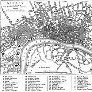
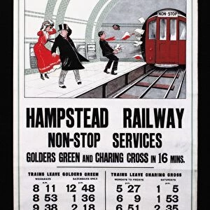
Map of London Underground railway, Hampstead Tube

Wall Art and Photo Gifts from Mary Evans Picture Library
Map of London Underground railway, Hampstead Tube
Map of London Underground railway extension, highlighting the recently opened Hampstead Tube (Charing Cross, Euston & Hampstead Railway), branching out to Golders Green and Highgate. Date: 1907
Mary Evans Picture Library makes available wonderful images created for people to enjoy over the centuries
Media ID 23269428
© Illustrated London News Ltd/Mary Evans
Brompton Cost Fare Finsbury Hammersmith Journey Kings Lines Metropolitan Piccadilly Price Railways Route Routes Stations Underground 1907
FEATURES IN THESE COLLECTIONS
> Europe
> United Kingdom
> England
> London
> Boroughs
> Hammersmith and Fulham
> Europe
> United Kingdom
> England
> London
> Sights
> Green Park
> Europe
> United Kingdom
> England
> London
> Towns
> Finsbury Park
> Europe
> United Kingdom
> England
> London
> Towns
> Golders Green
> Europe
> United Kingdom
> England
> London
> Towns
> Hammersmith
> Europe
> United Kingdom
> England
> London
> Towns
> Hampstead
> Europe
> United Kingdom
> England
> London
> Towns
> Highgate
> Europe
> United Kingdom
> England
> London
> Transport
> Stations
> Mary Evans Prints Online
> New Images August 2021
EDITORS COMMENTS
Step back in time with this print of the 1907 Map of London Underground Railway, showcasing the newly opened extension of the Charing Cross, Euston & Hampstead Railway. This intricate illustration highlights the branching out of the line to Golders Green and Highgate, adding to the extensive network of underground routes that revolutionized transportation in the city. Dating back to the Edwardian era of the early 1900s, this map offers a fascinating glimpse into London's transport history. The Charing Cross, Euston & Hampstead Railway, also known as the Hampstead Tube, was a significant addition to the Metropolitan, Hammersmith & City, District, Metropolitan District, and Great Northern, Piccadilly & Brompton lines that crisscrossed the city. Journeying through the map, one can see the various stations, including Charing Cross, Euston, Finsbury Park, and Kings Cross, each marked with their distinctive names. The fares and travel times between these stations are indicated, offering a glimpse into the cost of commuting during this period. This map not only serves as a historical record but also as a testament to the ingenuity and ambition of the engineers and planners who brought this extensive underground network to life. The intricate details of the map, from the winding tunnels to the carefully labeled stations, transport us back to an era of innovation and progress in London's transport history.
MADE IN THE USA
Safe Shipping with 30 Day Money Back Guarantee
FREE PERSONALISATION*
We are proud to offer a range of customisation features including Personalised Captions, Color Filters and Picture Zoom Tools
SECURE PAYMENTS
We happily accept a wide range of payment options so you can pay for the things you need in the way that is most convenient for you
* Options may vary by product and licensing agreement. Zoomed Pictures can be adjusted in the Cart.