Home > Africa > Egypt > Alexandria
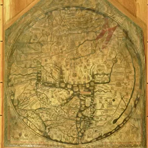
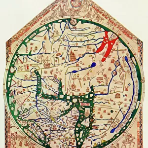
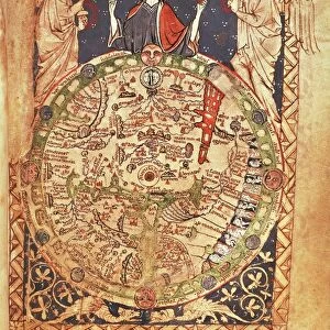
Hereford World Map, c. 1280, 1944. Creator: Richard de Bello

![]()
Wall Art and Photo Gifts from Heritage Images
Hereford World Map, c. 1280, 1944. Creator: Richard de Bello
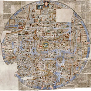
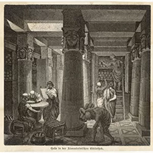
Hereford World Map, c.1280, (1944). Detail showing the Mediterranean coast and the Nile Delta in northern Egypt. The lighthouse at Alexandria, complete with flames, can be seen next to the mouth of the River Nile. Also shown are mythical creatures such as the winged salamander, unicorn or monoceros, and mandragora, as well as a real rhinoceros. Part of the Hereford Mappa Mundi at Hereford Cathedral. Attributed to Richard de Bello, the Hereford Mappa Mundi, drawn on a single sheet of vellum, is the largest known existing medieval map. From " British Maps and Map-Makers", by Edward Lynam. [Collins, London, 1944]
Heritage Images features heritage image collections
Media ID 19777276
© The Print Collector/Heritage Images
Alexandria Amphibian Britain In Pictures Collins Edward Edward Lynam Island Islands Largest Latin Lighthouse Lynam Mediterranean Sea Nile Nile Delta North Africa Rhino Rhinoceros Richard De River Nile Salamander Social History The Nile Unicorn William Collins William Collins And Sons William Collins Sons Bello Mandragora Mandrake Mappa Mundi Mythical Beast Mythical Creature Thirteenth Century
FEATURES IN THESE COLLECTIONS
> Africa
> Egypt
> Alexandria
> Animals
> Amphibians
> Salamanders
> Related Images
> Animals
> Mammals
> Muridae
> Fortior
> Animals
> Mammals
> Rhinolophidae
> Monoceros
> Arts
> Art Movements
> Medieval Art
> Arts
> Artists
> C
> Richard Collins
> Arts
> Artists
> C
> William Collins
> Arts
> Landscape paintings
> Coastal landscapes
> Nature-inspired artwork
> Arts
> Landscape paintings
> Waterfall and river artworks
> Nature-inspired paintings
EDITORS COMMENTS
This print showcases a remarkable piece of cartographic history - the Hereford World Map, created around 1280 and reproduced in 1944. Crafted by Richard de Bello, this medieval map is drawn on a single sheet of vellum and holds the distinction of being the largest known surviving map from that era. In this detailed close-up, we are transported to the Mediterranean coast and the Nile Delta in northern Egypt. The ancient city of Alexandria comes alive with its iconic lighthouse standing proudly next to the mouth of the River Nile, depicted with flames dancing atop it. What truly sets this map apart are its mythical creatures intermingling with real-world elements. From winged salamanders to unicorns or monoceros, mandragoras to even a rhinoceros, these fantastical beings add an air of enchantment to an already awe-inspiring creation. Part of the Hereford Mappa Mundi housed at Hereford Cathedral, this masterpiece offers insights into medieval geography and British history. It serves as a testament to human curiosity about our world's vastness during a time when exploration was limited. Preserved through centuries, this print allows us to appreciate not only Richard de Bello's artistic prowess but also gain glimpses into historical events and cultural beliefs that shaped societies long ago. A true treasure for those fascinated by maps, mythology, and social history alike.
MADE IN THE USA
Safe Shipping with 30 Day Money Back Guarantee
FREE PERSONALISATION*
We are proud to offer a range of customisation features including Personalised Captions, Color Filters and Picture Zoom Tools
SECURE PAYMENTS
We happily accept a wide range of payment options so you can pay for the things you need in the way that is most convenient for you
* Options may vary by product and licensing agreement. Zoomed Pictures can be adjusted in the Cart.