Home > Mary Evans Prints Online > New Images August 2021
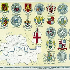
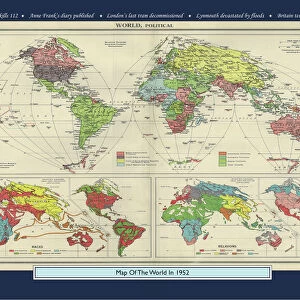
Map of London, 1952

![]()
Wall Art and Photo Gifts from Mary Evans Picture Library
Map of London, 1952
Map of London in 1952.
1952
Mary Evans Picture Library makes available wonderful images created for people to enjoy over the centuries
Media ID 23359222
© Mary Evans Picture Library
1952 Bermondsey Bridges Deptford Greenwich Holborn Isle Maps Poplar Scale Southwark Stepney Westminster
FEATURES IN THESE COLLECTIONS
> Arts
> Landscape paintings
> Waterfall and river artworks
> River artworks
> Europe
> United Kingdom
> England
> London
> Boroughs
> City of Westminster
> Europe
> United Kingdom
> England
> London
> Boroughs
> Greenwich
> Europe
> United Kingdom
> England
> London
> Boroughs
> Southwark
> Europe
> United Kingdom
> England
> London
> Related Images
> Europe
> United Kingdom
> England
> London
> River Thames
> Europe
> United Kingdom
> England
> London
> Towns
> Bermondsey
> Europe
> United Kingdom
> England
> London
> Towns
> Deptford
> Europe
> United Kingdom
> England
> London
> Towns
> Greenwich
> Europe
> United Kingdom
> England
> London
> Towns
> Poplar
> Mary Evans Prints Online
> New Images August 2021
EDITORS COMMENTS
Step back in time with this map of London as it appeared in 1952. This intricately detailed print, created by Terry Parker, offers a glimpse into the past, showcasing the city's layout before the significant changes that took place in the following decades. The River Thames winds its way through the heart of the city, with iconic landmarks such as Westminster Abbey, Tower Bridge, and Greenwich Park clearly visible. The map reveals the character of different areas of London during the 1950s. In the east, one can see the bustling docks of Poplar, Bermondsey, and Deptford, while in the west, the elegant streets of Kensington and Chelsea stand out. The City of London, with its financial district, is located in the northeast, while Holborn and Southwark can be found in the central and southwestern parts of the map, respectively. This map is a testament to the rich history and diverse character of London during the 1950s. It invites us to explore the city's past, allowing us to appreciate how it has evolved over the years. With a scale of 1:25,000, this map is not only an attractive piece of decor but also an invaluable resource for those interested in London's history and urban development. Whether you're an armchair historian, a London enthusiast, or simply someone who appreciates the beauty of old maps, this print of London in 1952 is a must-have addition to your collection. Let it transport you back in time and ignite your imagination as you explore the fascinating story of this great city.
MADE IN THE USA
Safe Shipping with 30 Day Money Back Guarantee
FREE PERSONALISATION*
We are proud to offer a range of customisation features including Personalised Captions, Color Filters and Picture Zoom Tools
SECURE PAYMENTS
We happily accept a wide range of payment options so you can pay for the things you need in the way that is most convenient for you
* Options may vary by product and licensing agreement. Zoomed Pictures can be adjusted in the Cart.